The new W light rail line opened on Friday. For the first two days the ride was free. There was like a street fair at each stop. It was a big celebration of mass transit.
I got on the Platte bike path near Alameda and headed North past the new animal shelter. It's a quality operation. I love the big silver dog.

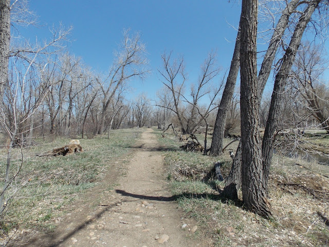
 From this spot to the Lakewood Gulch trail is all brand new trail. New sights to see.


 If you have a smartphone, use that number on the sign.
Go to RTDmobile.com and select "my stop". Punch in the number on your particular sign and it will tell you what buses serve that stop and the next three times each will stop. It's amazing.
I don't use RTD to commute but for carrying me to a specific drop zone or getting me back home they are the bomb.
I got on the Platte bike path near Alameda and headed North past the new animal shelter. It's a quality operation. I love the big silver dog.
Entering Frog Hollow Park. Looks like they've trimmed vegetation so you can see the river better.
That is the the Weir Gulch trail cutoff. Not a bad ride, not very long. Maybe 5 miles. You end up near the Bel Mar shopping center in Lakewood.. Today we're going to Golden.
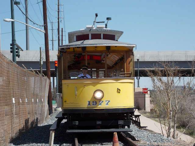
Old time Trolley came as far as he could to see the new light rail. These used to cruise all over Denver. The new light rail follows the Associated Railway right of way, where a trolley like this used to take the same route 60 years ago.
Back in the day, as late as 1997, this trolley was stationed at the old Forney Transportation building, which had been a trolley barn originally. Now Forney's has moved over by the Coliseum and R.E.I. is the new tenant. A trolley association was formed to care for the old gal. It still runs on weekends and Summer days. Back in 1997 when I took a ride on this trolley it went up the Lakewood Gulch all the way to the Federal bridge, then back. Now days it runs only as far as the aquarium, a mile less than it used to go.
Today was special. a passing of the torch. I'm glad #1977 came out to represent.
After I took that pic the future whizzed by.
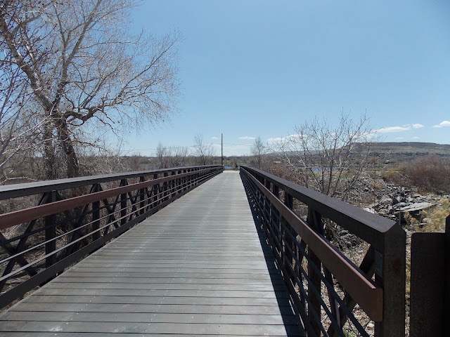
Here's the new Lakewood Gulch Trail. The Federal Station is in the distance.
The Trolley used to go up Lakewood Gulch. Here's the old railroad from 2008. Also the original Lakewood Gulch Trail
Now wide and open it used to be close and dangerous. This is August 2008
Subject to flash floods.
In 2008 there were the three players in Lakewood Gulch. The bike path, the water feature and the railway which can be seen on the right. That's where the light rail goes today.
2008 trestle didn't survive
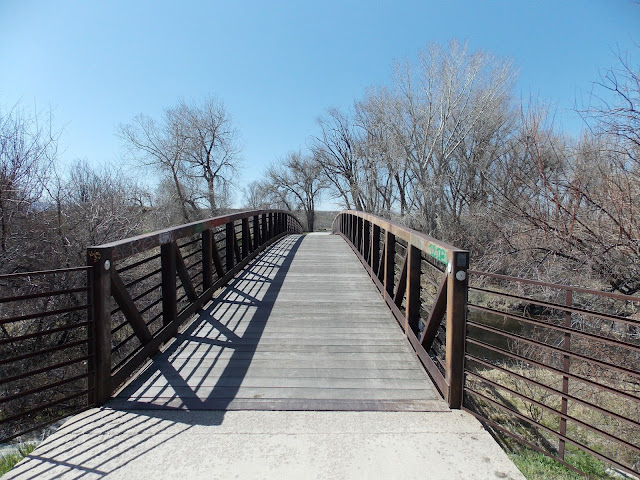
See the picture above and below. Both taken from the same spot.
You can compare old and new pictures, use the white building on the left as a reference. You can hardly see it in 2008, by 2011 it looked like this.
Same view February 2012:
Fast forward to today.
The entire light rail system was free today and I see a lot of people are taking a ride to Golden.
Every stop featured a carnival atmosphere with a lot of food, things to see and general promotion of that specific neighborhood. I suppose if I hadn't been in a hurry I could have jumped off here and there. But no, not today. This is Sheridan station.
Here's Oak station. One thing I noticed between stations is new bike trails. It's not quite continuous but meets up with enough other trails to maybe provide a more direct route from Denver to Golden. I'm going to have to check on that.
Park & Ride at Federal Center. Big party
Then I got off in Golden. There stands the County Government building. You can go around the left or right side of the building. I went right which was also down. I went around the building then followed the road down to town.
Art in a traffic circle. Turn left on Ford st.
Follow Ford downtown.
There's some people waiting for the Coors Brewery Tour.
What did Coors do during Prohibition? They made malted milk.
OK, so you've been cruising along Ford Street, keeping downhill. When you get to 10th st. turn right.
Go a half block on 10th and you'll see Tucker Gulch on your left. Go up
Tucker Gulch is maybe 0.5 miles.
When you reach the Clear Creek Trail you'll see Church Ditch, which happens to be dry. It will fill with water very soon.
***
The Church Ditch is a carrier ditch operated by the Church Ditch Water Authority under Colorado statutes with decreed absolute priorities to 113.03 cubic feet of water per second from Clear Creek.
The Church Ditch begins at a headgate in Clear Creek, near Golden, Colorado, and runs twenty-six (26) miles in length through Jefferson County until it ends near the intersection of 100th Avenue and Simms Street at the Wilson Flume formerly known as the Ketner Flume. www.churchditch.org
With the Tabletop Mesa in the background we start down the trail.
There's a map and description of the trail here:
Tabletop Mesa with the massive Coors Brewery in the foreground.
This the bridge over 58th.
It was Saturday and the Beer Train was idle.
It looks kind of grey now but this will turn green very soon.
One of many bridges over Clear Creek.
I saw several gold prospectors today.
There's one in the middle of Clear Creek.
The bridge in the far distance was built a few years ago and disrupted the trail for a while. Now everything is Hunky Dory.
A lot of water storage along Clear Creek and all manner of wheeled vehicles.
Another big lake.
Bird Island full of birds as usual.
I caught some single track along the way.
This is how you suppress Beaver damage. You see damage, you protect tree, Beaver chews on a less important tree. At least the people don't hunt them down and kill them for following their natural instincts like they do Coyotes. (Except in Boulder where hazing is preferred)
I saw horses but they weren't interested in me.
OK, we're about a block from Kipling. The quickest way to cross is to go straight here, on the dirt. You'll come to an office parking lot, take that to Kipling. Be careful crossing.
Bing bang boom you're across and back on the trail.
It was a beautiful day for a ride. Sunny and warm.
There are multiple parks and tons of picnic stops along the trail.
I saw a couple baseball games being played.
Stopped here for water and a cliff bar.
Some more single track along the creek.
Bridge over Clear Creek.
This spot develops a green canopy during the Summer.
Clear Creek is a great ride.
Another baseball game. Speaking of which the Rockies could be contenders if they stay healthy, especially the starting pitching staff.
The trail ends for a couple blocks and you ride on a road.
If you follow the news this is where a truck hit one of these towers recently and some folks were evacuated.
After two blocks it's back to the trail.
Runoff very low right now. That is sure to change soon.
Soon the magnificent Ralston Creek Bridge appears in the distance.
To me it looks like a ship. Here's a view from the stern.
Another angle.
Take this bridge to head up Ralston Creek. To see my take on Ralston see older posts. I once rode up Ralston and down Clear creek, gotta do that again.
You can still see the sign. Barely.
There's some single track.
Lowell Ponds Wildlife Area.
The water diversion to Fisher Ditch.
Fisher Ditch just after the diversion.
My old dead tree friend who maybe lived too close to Fisher Ditch who was killed around 2005. I stop and pay my respects every time I go by. We used to hang out some back in the day.
It used to bug me that maybe the Fisher Ditch company killed Old Larry here, as well as several other large trees along it's path.
But how can you stay mad at a ditch? These things were dug some 150 years ago by hand. It's a testament to quality (and maintenance) that they still work today.
Looking upstream at Clear Creek.
Looking Downstream.
There are bees so something must need pollinating.
There was one little spot that was closed but it's an easy crossing.
Mind the gap.
You can walk your bike across easily if you look to the left here. There's a well worn path.
There is a train and a car bridge but whatever this is for it's aligned differently than either of those. Maybe the light rail to Westminster and Boulder? Stay tuned and I'll find out.
Oh my, a landmark is gone. There used to be a heavily graffito tagged mobile home up on the left where that pile of stones is. That was your cue that Federal Avenue is ahead.
Sometimes I take Clear Creek to the Platte, turn right, go 1 mile to Sand Creek and ride Sand Creek to Colfax in Aurora. Not today though. I caught a bus back to Denver on Federal.
Go to RTDmobile.com and select "my stop". Punch in the number on your particular sign and it will tell you what buses serve that stop and the next three times each will stop. It's amazing.
I don't use RTD to commute but for carrying me to a specific drop zone or getting me back home they are the bomb.
No comments:
Post a Comment