I took a great ride yesterday. Golden to Aurora on three bike paths. First I caught an RTD bus to Golden. I caught the 16L at Lipan and Colfax and got off at 10th and Washington in Golden.


 You can click to enlarge this map. Here we are on the Clear Creek Trail.
 Heading down the trail.

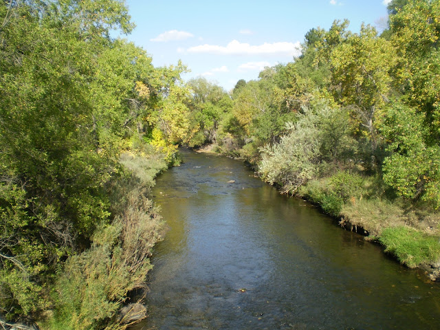
 Clear Creek looks real nice this time of year.
 Unidentified scat. Top one is probably Fox the next two probably Coyote.


 Single track along Clear Creek.
 Such a beautiful time of year.


This is where you re-join the trail.


 Good ol' Clear Creek. We're in Adams County. If you read the newspaper you know there is a surprising amount of corruption in Adams County. You go criminals!
Their trail making prowess is not in question though.
 Near the Fisher Ditch I stopped to see my dead tree friend. Wow, it's all overgrown, you can hardly see what's left of her.
 I got in closer and put my bike in for scale. It was a huge tree. I used to hang out under this tree ten years ago. Then one day they cut this huge tree and several large trees near the Fisher Ditch. Maybe the water owners decided the trees drank too much. Vegicide ensued.
At first I was mad at the Fisher Ditch, but how can you stay mad at a ditch?


 I also saw a bunch of rough edges along Clear Creek. They used to smooth these out. Now the city/county/state is broke. I'm on a mtn bike so no problemo but I feel sorry for the roller bladers.

 Jesus on a tortilla? Heck I saw Marilyn on a bike path


 Next you see the dam, needed for the Lower Clear Creek Canal and the Colorado Agricultural Canal diversions.
 This is the beginning of the Lower Clear Creek Canal. The Colorado Agricultural Canal branches off in about a half a mile.

 There seems to be more water going into the canals than to Clear Creek. This is the amount going to Clear Creek.
 There's your Clear Creek after the dam.


 There's I-25 in the distance
 Almost to the Platte River now.
 There are benches all along the trail.
 Under I-25
 Here we are at the end of Clear Creek. Take this bridge over Clear Creek to the Platte River Trail towards Denver.
 I went over the Platte to check a construction zone
 The trail on the South side of the Platte is closed, the trail on the North side is open.


 Here's a couple close ups.

 Here's a nice turn out along the trail.

 Looking up the Sand Creek Trail.
 Sunset on Sand Creek.

 There's the Sapp Brothers Truck Stop off I-70.
 Just past the Sapp Bros You encounter construction. No detour, just be alert.
 I've posted many pictures of this stream. This is the first time I've seen it running through a culvert. Massive construction projects are going on all along this ride.
 It was dark by now but I took one pic with a flash. There is a very short detour around the light rail construction zone.

Then I saw a really dirty trail closed sign. I was a mile or so from the end of the trail. I went around the sign. The trail was fine. There was no trail closed sign at the other end of the trail.
*Equipment update: I had been using Nite Rider headlights but my battery died and a replacement battery was about $200. I went to Turin Cycle to check their lights out. I ended up getting A Serfas light. Tiny little tube you can mount on the helmet or handlebars. Made in China, around $150. It puts out 500 Lumens in a nice beam. Tonight was my test ride and it gets a great review. It is rechargable via USB cable or wall plug.


(from RTD) The MyStop system features speech recognition and touch-tone technology. Once you’re dialed in, you’ll hear “RTD’s MyStop automated schedule. Enter the 5-digit stop number you want schedules for…” Say your stop number and you’ll be given the next three scheduled arrivals for today. If there are multiple routes available, you’ll be prompted to pick your route. To repeat the information or choose a different time, day, route or stop number, simply follow the prompts.
Knowledge is power. Clear Creek to Sand Creek encompasses a huge drainage. Also a four star ride.

Once you're off the bus go a couple blocks on 10th to Ford Street. There you'll see Tucker Gulch. Take Tucker Gulch up to the Clear Creek Trail.


 You can click to enlarge this map. Here we are on the Clear Creek Trail.
Go past the massive Coors Brewery.

I did not see the Beer Train this time.

There was a short detour due to road construction. You ride down a dead end road and get back on the trail by the grain silos.

Here's the other end of the detour.

With gold near $2,000 an ounce, a lot of folks were looking for it in Clear Creek. I saw at least a dozen prospectors.

 Clear Creek looks real nice this time of year.
There is a section with a bike path on one side and a walking path on the other.

 Unidentified scat. Top one is probably Fox the next two probably Coyote.
 Coyotes tend to poop in the middle of a trail. Many other animals will pass by and smell them, it is a form of communication. I'm glad humans have email.


I crossed Kipling here. The path takes you up a hill so you can cross at a light. This is quicker but watch the traffic.

 Single track along Clear Creek.
Starting to see some fall colors.


You go through one park after another. It's a really nice ride.


You leave the trail for about 200 yards, it's well marked.


This is where you re-join the trail.
Here's a couple shots of the bridge to the Ralston Creek Trail head. That bridge reminds me of a sailing ship.


From this bridge it's 10.7 miles from Ford and 10th in Golden and 7 miles to the Platte river confluence. The entire trip is about 30 miles.

You travel through a State Wildlife Area.


Their trail making prowess is not in question though.
 Near the Fisher Ditch I stopped to see my dead tree friend. Wow, it's all overgrown, you can hardly see what's left of her.
At first I was mad at the Fisher Ditch, but how can you stay mad at a ditch?
Here's a shot of the good ol' Fisher Ditch. Isn't it awesome? Colorado is a semi arid state. The fact that people dug these waterways 150 years ago and they still deliver water to their shareholders and the fact that there are so many canals and ditches in the area. We'll cross or go near Tucker Ditch, Farmers Highline Canal, Church Ditch, Agricultural Ditch, Welch Ditch, Wannamaker Ditch, Eskin Ditch, Rocky Mountain Ditch, Croke Canal, South Boulder Diversion Canal, Reno Ditch and Swadley Ditch. OK, all these were dug by hand and are still serving their purpose all these years later.
 Isn't it awesome? Colorado is a semi arid state. The fact that people dug these waterways 150 years ago and they still deliver water to their shareholders and the fact that there are so many canals and ditches in the area. We'll cross or go near Tucker Ditch, Farmers Highline Canal, Church Ditch, Agricultural Ditch, Welch Ditch, Wannamaker Ditch, Eskin Ditch, Rocky Mountain Ditch, Croke Canal, South Boulder Diversion Canal, Reno Ditch and Swadley Ditch. OK, all these were dug by hand and are still serving their purpose all these years later.
 Clear Creek.

I saw Winnie the Pooh. What substance does he crave? Honey (or Hunny)!

Right next to Winnie there were several bee hives. Let's hope they avoid that nasty complete colony collapse syndrome.

When you get to the Graffito tagged mobile home you know you're at Federal and can catch a bus if you're tuckered out. Not today, I'm feeling great.

During the spring flood season a significant log jam piled up here.


 Jesus on a tortilla? Heck I saw Marilyn on a bike path
In the distance you can see the concrete structure that marks the beginning of the Little Dry Creek Trail.

To continue on Clear Creek go over the railroad tracks.

Little Dry Creek is a nice ride. I gotta do that and Big Dry too. OK, that's next. That's a whopper .
.
 .
.It dawned on me that I was going to be too late to dine at Smokey's, I had several power bars and some granola left so  I was good to go. It's weird, there are some places I've only been by bike.
Smokey's is one of those. When they say closed at 5 they mean it. I got there at 5:10 and it was locked tight. I was good to go. It's weird, there are some places I've only been by bike.
Not too far from Smokey's the trail goes by the reservoir.


Looking down the Lower Clear Creek Canal.

 There seems to be more water going into the canals than to Clear Creek. This is the amount going to Clear Creek.
 There's your Clear Creek after the dam.
It's a nice view. 

Continuing along the Lower Clear Creek Canal.

OK, boys and girls, here's something brand new. This is where they split the Lower Clear Creek Canal into two. To the left is Colorado Agricultural Canal, to the right is Lower Clear Creek Canal. this is all new equipment and new concrete, the old gear is gone.

The picture below is the old setup. The new system looks fully automated, I think you could close the gate electronically. Someone used to have to hand crank it.


There goes Lower Clear Creek Canal in it's new spill way. then down the old canal below.

There goes the Colorado Agricultural Canal.

Water is important.

If you see the water start to rise climb to high ground.

 There's I-25 in the distance
 Almost to the Platte River now.
 There are benches all along the trail.
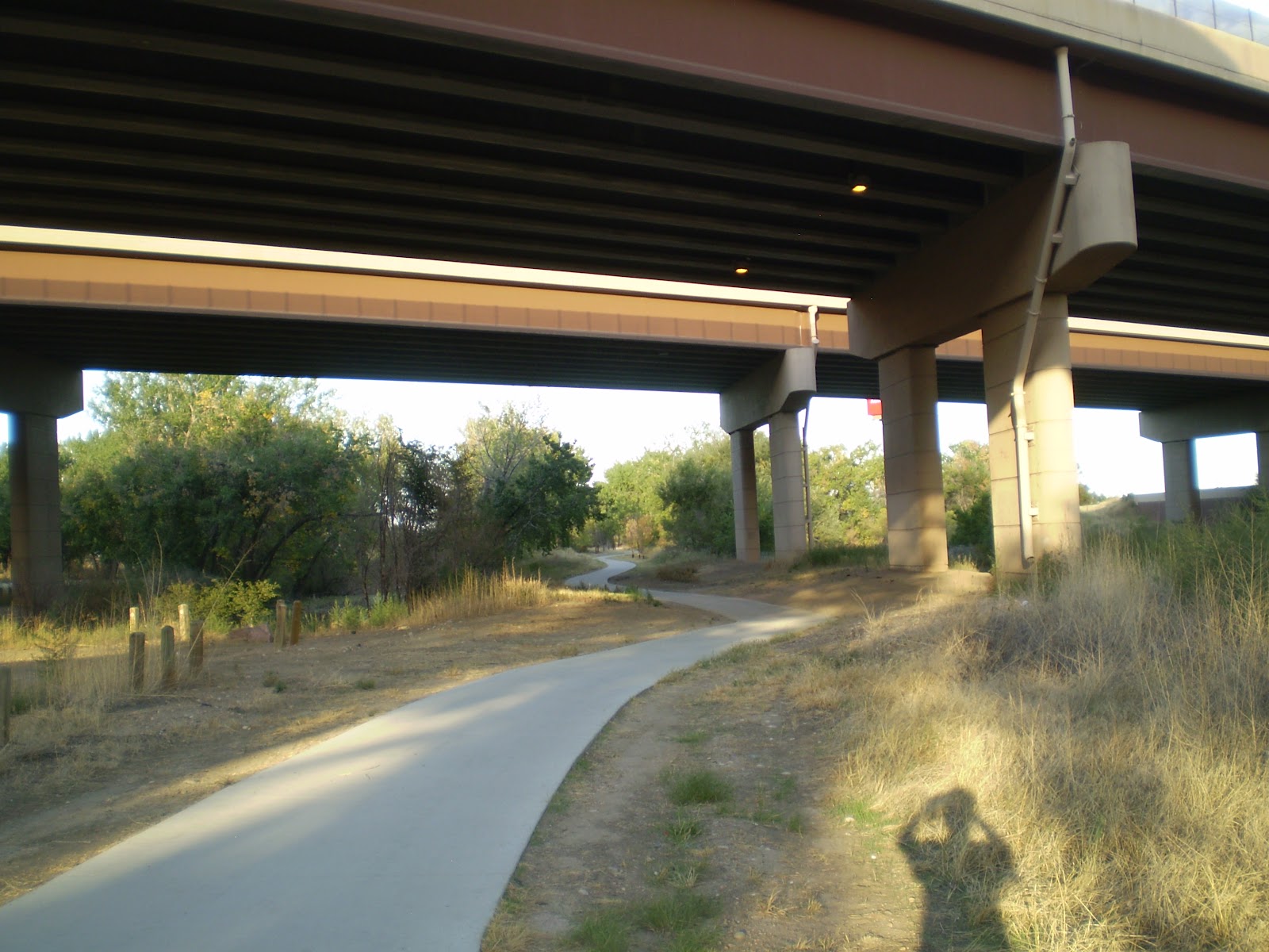 Under I-25
 Here we are at the end of Clear Creek. Take this bridge over Clear Creek to the Platte River Trail towards Denver.
 I went over the Platte to check a construction zone
 The trail on the South side of the Platte is closed, the trail on the North side is open.
Clear Creek empties into the Platte here. Clear Creek looks kinda green and stagnant.

There is some highway construction along the Platte but no detours necessary.

Look there's a foot bridge over the Platte. Looks like they're going to widen these I-76 bridges.

You can just see the water reservoir, former gravel pit old gravel pit that got built a few years back. My blog documents the changes in the bike path at the time. Everything's hunky-dory now. There's a twin reservoir on the other side of the Platte, it's hard to see from here.

OK, so you head West on the Platte River Trail one mile then turn up Sand Creek.

This is from the bridge that leads to Sand Creek. They're fixing I-270 bridge. 

There's Good Ol' Sand Creek meeting the Platte.
Sand Creek Trail, looking at the most excellent city of Denver in the distance.

Hey this is a new picnic shelter along the trail. Good place for a break.

This sign was next to the shelter. It talks about how they've revitalized the area and I can testify that every word is true. Click to enlarge.
Some weird white substance leaked from the freeway onto the trail. Ewww! I think those are Coyote Tracks because someone walking their dog would probably not let their dog walk through unknown goo.


 Here's a nice turn out along the trail.
Looking down the Sand Creek Trail..

 Looking up the Sand Creek Trail.
I took a picture of some mushrooms. The bigger one was about the size of an egg.


 Just past the Sapp Bros You encounter construction. No detour, just be alert.
 I've posted many pictures of this stream. This is the first time I've seen it running through a culvert. Massive construction projects are going on all along this ride.
 Oh My, I posted on my first Sand Creek Trail post that this area was where the RTD Light rail line to DIA would be located. Lordy be there is is. Beyond the fence you can see the light rail bridge being built over sand creek. It will travel across a former runway at the old Stapleton Airport on the way to DIA.


Then I saw a really dirty trail closed sign. I was a mile or so from the end of the trail. I went around the sign. The trail was fine. There was no trail closed sign at the other end of the trail.
*Equipment update: I had been using Nite Rider headlights but my battery died and a replacement battery was about $200. I went to Turin Cycle to check their lights out. I ended up getting A Serfas light. Tiny little tube you can mount on the helmet or handlebars. Made in China, around $150. It puts out 500 Lumens in a nice beam. Tonight was my test ride and it gets a great review. It is rechargable via USB cable or wall plug.

The bridge over Sand Creek on Havana.

I followed Havana to Peoria and turned South to Colfax to catch a RTD 15 to Denver. I could have gone a few more miles on the Sand Creek & Toll Gate Creek trails but I was tuckered out.
When you reach an RTD bus stop, note the 5 digit number on the bus stop sign. Call 303.299.6000, options 1, 1
(from RTD) The MyStop system features speech recognition and touch-tone technology. Once you’re dialed in, you’ll hear “RTD’s MyStop automated schedule. Enter the 5-digit stop number you want schedules for…” Say your stop number and you’ll be given the next three scheduled arrivals for today. If there are multiple routes available, you’ll be prompted to pick your route. To repeat the information or choose a different time, day, route or stop number, simply follow the prompts.
Knowledge is power. Clear Creek to Sand Creek encompasses a huge drainage. Also a four star ride.
1 comment:
Thanks for the great post! I love your photos of Clear Creek Trail, and I'm wondering if you would be willing to share one for a list we're creating of Top Outdoor Activities near Denver. We want to include Clear Creek Trail on the list, but have been struggling to find a good photo. When it's finished, the list will look something like this one, which we created for Boulder: https://www.sportody.com/colorado/boulder/
If you're willing to share a photo, we'd greatly appreciate it! I especially like this one in particular: http://1.bp.blogspot.com/-JxO7jyEzsUQ/Tosu8M8rW1I/AAAAAAAAEdA/oqUK1vU9E4Q/s1600/Pictures+003.jpg
Let me know what you think!
Haley Dilling
VP of Marketing
Sportody
Post a Comment