I read the newspaper every day. Since I bought a smart phone I can get most news there but I like reading the paper. That's where I read about a year ago that they were studying whether or not to raise Chatfield lake's water level to store more water. In Saturday's Denver Post there was a big article informing me that the plan had moved forward. The environmental impact statement was released Friday June 8, 2012, triggering a 60 day public comment period. Chatfield dam was built for flood control, not storage. Unfortunately if this happens it would wipe out wetlands and a cottonwood forest birds depend on.

I plan to comment in favor of the birds and the trees. I know we need water but there's got to be a better way. I took a ride around Chatfield today to see what we would lose if this happens.
I caught the light rail From Alameda to the Mineral Station.
 After you get off the train cross over Santa Fe to the Platte River Trail.
 There's the trail right there. Turn left on the Platte.

The Platte is very low this year.

Once in the park bypass the dog park keep left.
 Soon you'll see the dam.
 If the plan proceeds the boat launch will be underwater.
 The same with this swim beach along with all the trees.
 My most favorite single track along the shore will be gone too.
 Of course they can relocate trails, boat ramps and park areas, but not the trees.
 To ride the primitive single track head to the West end of the swim beach parking lot.
 There it is headed to the left.
 Bumpy asphalt at first gives way to dirt single track.
 It was a really nice ride through the Cottonwoods.

Sometimes this section is underwater. Soon to be permanently.

Viva La Beaver!
 After winding through the trees you cruise through a meadow. All will be submerged.

I found a few tracks.


 .
.


I usually listen to music on my rides but today my headphone cord broke when it got caught on a branch. It was a blessing in disguise, as I sat on this beach all I could hear was babbling water and a whole bunch of birds. It was amazing, probably 20 different calls by various species. After listening for about 15 minutes I caught the sound of a jet but for those 15 minutes it was really nice to hear only nature sounds.


 Or you can see Mr. Beaver here:
And who else lives in Mr. Beavers pond? Mr Turtle, who I zoom in on. He had one eye out of the water watching me.
You pass a secluded lake, known only to animals birds and the users of this trail. As usual I saw no one else on the dirt path all day.
 Another view of hidden lake.
 This trail along the Platte is worth saving. Too many animals call this home.
 The hidden jewel of Chatfield.

 Yet another one.
 A couple of shots of another dam.

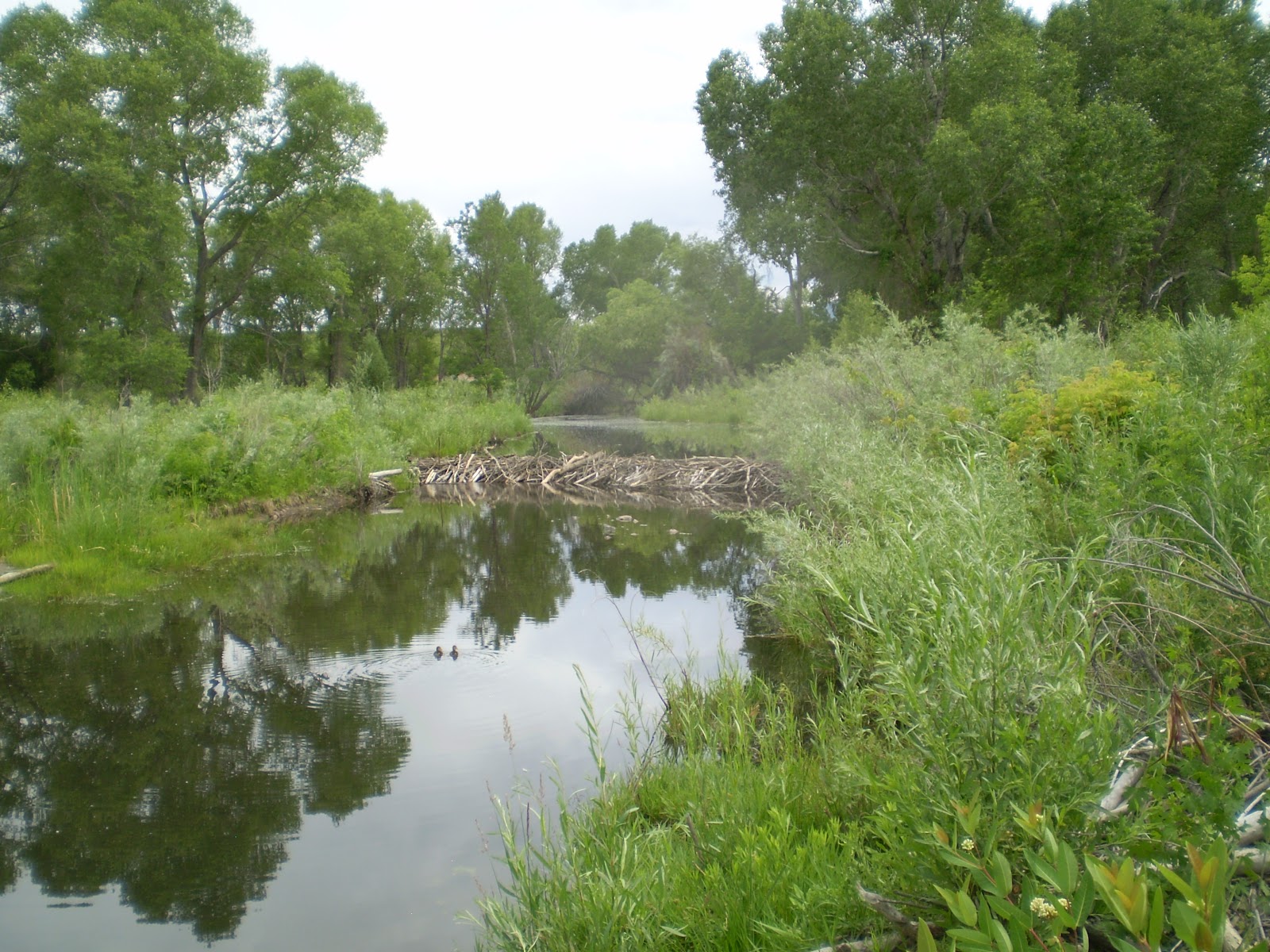
 The State Park workers take Beaver felled trees and use a chain saw to cut them into Beaver size logs.That tells me these Beavers are being allowed to thrive, creating more wetlands.
 There were numerous Beaver ponds. I set my bike down and walked along the edge of one. Big frogs kept jumping into the water before I could get a picture. Then I saw this guy. Frog upper left corner:
 Beaver pond.


I plan to comment in favor of the birds and the trees. I know we need water but there's got to be a better way. I took a ride around Chatfield today to see what we would lose if this happens.
I caught the light rail From Alameda to the Mineral Station.


The Platte is very low this year.

Once in the park bypass the dog park keep left.


Sometimes this section is underwater. Soon to be permanently.

Viva La Beaver!


I found a few tracks.


Single track through the meadow.

OK, once the single track empties into a parking lot you're at the South end of the lake. There is a bridge over the Platte just before it enters the reservoir. Look to the left or right just before the bridge, that's the Platte Trail. I've ridden down towards the lake but never up. Since this would all be inundated I better check it out now. It turns out there are all kinds of single track up there. Very secluded and natural too.
Here's a nice run through the trees.

Grass and trees.

Then I met up with the asphalt path right along the Platte.

Then I started noticing a lot of Beaver Dams.

It was really nice up the Platte.

I usually listen to music on my rides but today my headphone cord broke when it got caught on a branch. It was a blessing in disguise, as I sat on this beach all I could hear was babbling water and a whole bunch of birds. It was amazing, probably 20 different calls by various species. After listening for about 15 minutes I caught the sound of a jet but for those 15 minutes it was really nice to hear only nature sounds.

I'm going to ride this path a lot before it disappears.

I wish I'd tried this trail earlier.

Viva La Beaver!


Then I saw a pretty good size Beaver dam.


Then I saw the Beaver Lodge. I sat next to it and waited.

If you look closely you can see Mr. Beaver swimming towards the camera.
And who else lives in Mr. Beavers pond? Mr Turtle, who I zoom in on. He had one eye out of the water watching me.
You pass a secluded lake, known only to animals birds and the users of this trail. As usual I saw no one else on the dirt path all day.


Another Beaver dam.


Finally I came to this spot where the State Park ends.

The trail continues but I decided to stop here today. I'm coming back to go the rest of the way. According to my GPS I was less than a half a mile from Waterton and the beginning of the Highline Canal. After reaching that spot I could ride the epic bike path of Denver, The Highline Canal from beginning to end.

Beavers are good engineers.

I saw a few deer. Photographed one.

When I came back down the trail I came out here, next to the bridge.

Then I went down the trail towards the lake.

The trail turns to dirt single track.

Once I reached the lake I turned around and headed back. Here's a shot of a bunch of cattails and various wetland features. This would all be flooded.

Looking out over the lake.

South Platte River Valley.... changing again.

I saw a lot of birds on this ride including a Great Blue Heron. I'm not sure what kind this is but I'm sure he is against the plan to enlarge Chatfield.

This group area would be unaffected. This side of the lake has steep bluffs by the shore.

This "tower" has been re built. It used to feature wooden stairs, wooden rails and a wooden table.

It has a much cleaner feel to it and you can't carve your initials on anything.

You can see the far side of the lake, all those trees will die.

The path on this side of the lake is safe. Too high up to get flooded.

Here's a nice bench to gaze out over the lake.

Single track goes down to the waterline. The trees in the foreground are safe but not the ones closer to shore are not.

The campground is also safe from flooding.

Almost all the way around now..

Magpie on a tree.

Asphalt trail is kind of beat up.

This single track will be underwater.

There is a nice picnic area.

In the distance you can see the Marina, it will have to be relocated.

This is the trail that leads to the dam.

When you reach the dam, climb up to the top.

There's the objective, the top of the dam.

The dam.

Here we are at the top.

See that stop sign in the distance? That is where the Highline Canal is.

Now you can see a huge Cottonwood forest. All would be killed if flooded.

Habitat is the key to wild life. If you kill off the tress it will degrade the experience for everyone.

All those trees, think about all the critters that live there. Raising the water level would jeopardize them all.

The road on top of the dam leads back to the starting point.

There is Denver in the distance. From the top of the dam.

On the right you can see the road down the face of the dam.

Whee! down the hill then back to the Mineral Light Rail Station.

I did see one huge scat deposit. Well over two feet long.

Well that's it. I've decided on my next ride I will come over the top of the dam first, then explore that Cottonwood forest, then ride all the way up the Platte to the end of that trail.
If this plan goes forward it will be at least three years before the water level is raised. That gives a few years to explore these awesome trails.
No comments:
Post a Comment